


Old Port of Cartagena Nautical Chart by Heather, 1802: Murcia, Spain, Fortifications, Landmarks
Only 1 in stock
-
Handmade in the USA
![]()
Your map will be handmade in the US
The Unique Maps Co. has state of the art production facilities in North Carolina and Michigan, and specialist large format facilities in New Jersey and California. Your map will be printed, framed and personalised in the US.
Making and dispatching maps locally keeps delivery times down (2 to 3 days) and means your map should always arrive in perfect condition.
I also have production hubs in 22 countries around the world, which means you can buy this map as a gift for someone and I will make and deliver the map locally. They won't have to pay any tax or import duty.

-
Free delivery
in 2 to 3 days
Delivery in 2 to 3 days
Your map should be delivered in 2 to 3 working days with free delivery.
Express delivery is available at checkout which can reduce the delivery time to 1 to 2 days.
Please note that personalised maps, and larger framed maps, can take longer to produce and deliver.
If you need your order to arrive by a certain date, contact me and we can discuss your options.
-
Premium hardwood frames
Premium hardwood frames
My framed maps are handmade by professional, experienced framers from sustainably sourced hardwoods.
This means your framed map will feel solid and well-made.
My standard frame colours (black, dark brown, white, oak and gold) are available for all map sizes worldwide.
Custom framing is available for an additional fee.
-
Certified sustainable +
we plant trees🌳
Sustainability & Tree Planting
Here at The Unique Maps Co., we have an unusually high affinity for paper. After all, without paper, there can be no maps!
That's why all of our paper, frames and packaging are from FSC certified sources.
But we don't stop there. We've partnered with Treeapp to plant trees around the world.
If you spend $60 or more, we'll plant a tree in your name.
- 5 stars 'Excellent' rating on Trustpilot
Custom map sizes are available
At The Unique Maps Co., every order is processed and made by hand. There is no mass production and every map is custom made to order.
This means that I can tailor your map so that it perfectly fits a space on your wall, or a frame that you already own.
To order a custom sized map, select the size closest to what you need, and then select 'customise the size?' from the options below.
Custom sizing is free for large maps over 100cm or 40 inches, but for smaller maps there will be an additional small fee.


Or try searching for something!
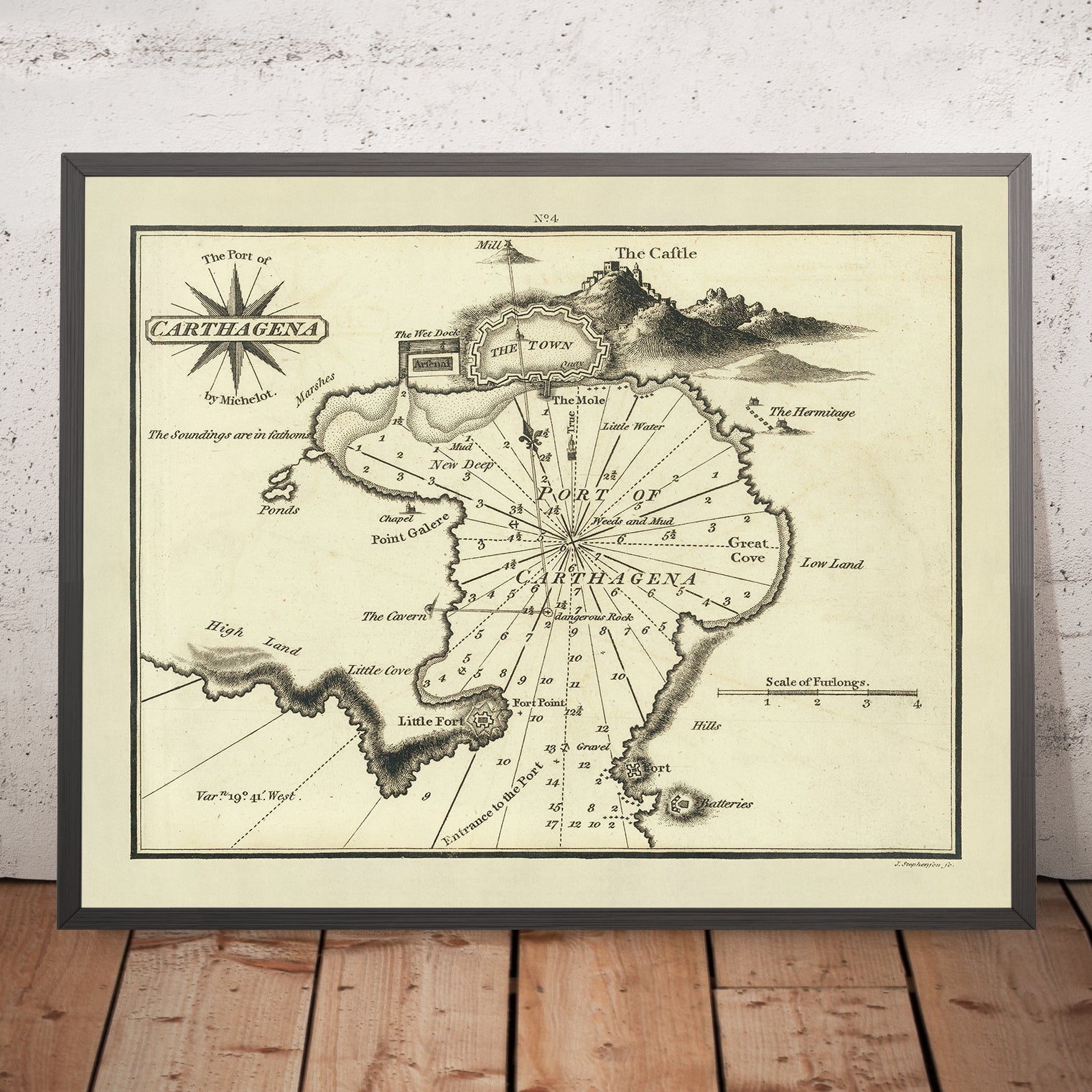
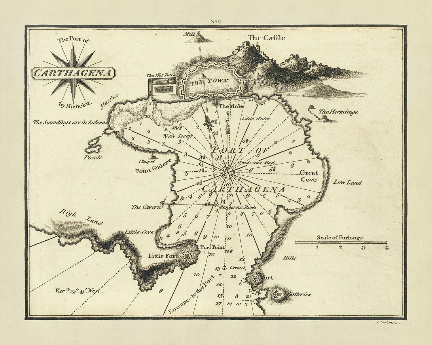
The Port of Carthagena: A Rare Nautical Chart by William Heather
Immerse yourself in the rich maritime history of the early 19th century with "The Port of Carthagena," a rare and exquisitely detailed nautical chart created by the esteemed British cartographer William Heather in 1802. This chart not only marks a significant point in cartographic history but also serves as a crucial navigational tool that provided mariners with essential information about the harbor at Carthagena, Spain. Heather's work is celebrated for its precision and artistic merit, setting a high standard in the tradition of British chart making.
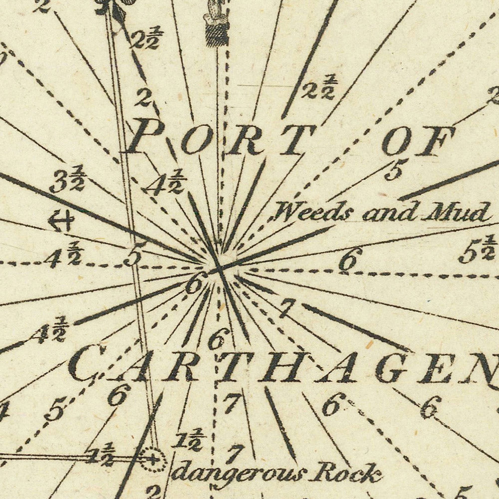
This chart is distinguished by its meticulous attention to detail, which includes soundings, navigational aids such as a compass rose, and currents, making it an invaluable resource for understanding the maritime landscape of the time. The chart also features a pictorial representation of the town and fortress, illustrating key landmarks such as the castle, the arsenal, and various fortifications. These elements not only aid in navigation but also provide a glimpse into the strategic importance of Carthagena as a fortified maritime hub.
William Heather's chart is part of his pioneering series, "The New Mediterranean Pilot," which was the first English collection of ports of the Mediterranean, despite similar efforts having been made earlier in France, Italy, and Spain. This chart stands out for its artistic finesse, largely attributed to the fine engraving skills of John Stephenson, a noted London engraver whose monogram adorns the piece. This collaboration highlights the era's intertwining of art and science in the service of exploration and commerce.
The rarity of this chart adds to its allure and value, making it a prized possession for collectors and historians alike. As part of Heather's ambitious project, this chart is one of the few surviving pieces from a collection that rarely appears on the market. Its scarcity underscores the chart's significance as a cultural and historical artifact, offering a unique window into the maritime practices and geographical knowledge of the early 1800s.
In conclusion, "The Port of Carthagena" is more than just a navigational aid; it is a masterpiece of cartography that embodies the spirit of an era when maritime exploration and charting were paramount. Owning this chart is akin to possessing a piece of maritime history, a testament to the skill and dedication of early cartographers like William Heather, whose work continues to inspire and inform even today. This chart is not merely a collector's item but a source of inspiration and historical insight, reflecting the strategic, commercial, and artistic endeavors of its time.
Notable Places on This Map
- The city of Cartagena
- The surrounding coastline
- The entrance to the port
- The castle
- The mole
- The little water
- The arsenal
- The wet dock
- The quays
- The hermitage
- The great cove
- The low land
- The hills
- The batteries
- The entrance to the port
Notable Features & Landmarks
- Fort Point
- Little Fort
- Fort Grave
- The Cathedral
- The Church of San Pedro
- The Royal Hospital
- The Military Hospital
- Plaza de Mercado
- Mercado de San Francisco
Historical and Design Context
- Created by William Heather in 1802
- A nautical chart showing detailed maritime navigational features
- Includes soundings, topographical features, anchorages, and several points of interest
- Finely engraved and signed in monogram by John Stephenson
- Part of Heather's "The New Mediterranean Pilot," the first English collection of ports of the Mediterranean
- Extremely rare on the market, adding to its value as a collector's item
Please double check the images to make sure that a specific town or place is shown on this map. You can also get in touch and ask us to check the map for you.
This map looks great at every size, but I always recommend going for a larger size if you have space. That way you can easily make out all of the details.
This map looks amazing at sizes all the way up to 50in (125cm). If you are looking for a larger map, please get in touch.
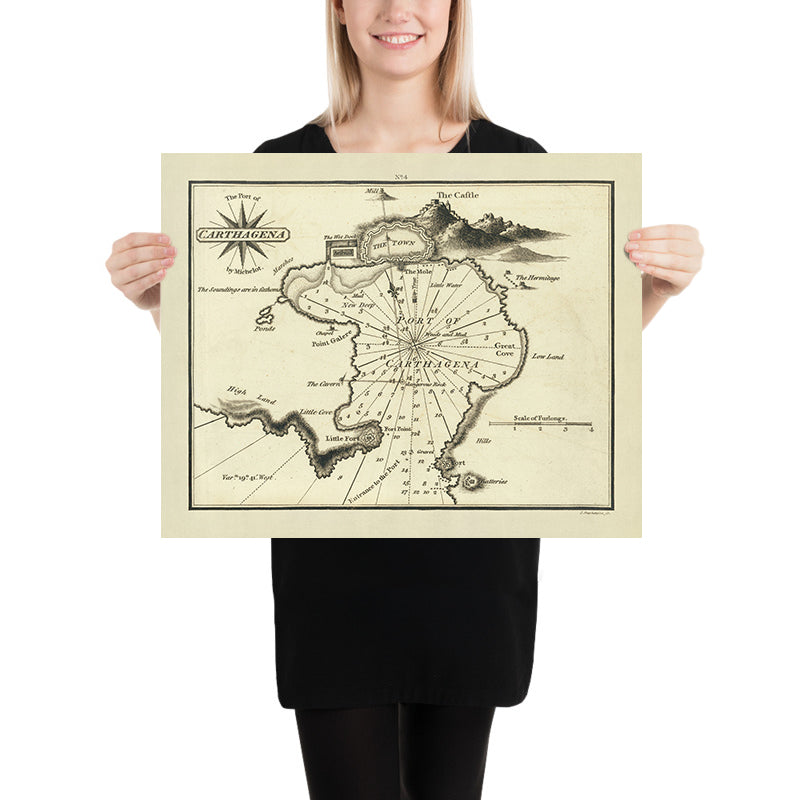
The model in the listing images is holding the 16x20in (40x50cm) version of this map.
The fifth listing image shows an example of my map personalisation service.
If you’re looking for something slightly different, check out my collection of the best old maps to see if something else catches your eye.
Please contact me to check if a certain location, landmark or feature is shown on this map.
This would make a wonderful birthday, Christmas, Father's Day, work leaving, anniversary or housewarming gift for someone from the areas covered by this map.
This map is available as a giclée print on acid free archival matte paper, or you can buy it framed. The frame is a nice, simple black frame that suits most aesthetics. Please get in touch if you'd like a different frame colour or material. My frames are glazed with super-clear museum-grade acrylic (perspex/acrylite), which is significantly less reflective than glass, safer, and will always arrive in perfect condition.
My standard frame is a gallery style black ash hardwood frame. It is simple and quite modern looking. On maps up to 36 inches (91cm) the frame is 1.5-3cm (0.6in to 1in) wide. I use thicker frames on larger maps - usually between 35 and 60mm (1.4in to 2.4in).
In all cases I use super-clear acrylic (perspex/acrylite) for the frame glass. It's lighter and safer than glass - and it looks better, as the reflectivity is lower.
All frames are provided "ready to hang", with either a string or brackets on the back. Very large frames will have heavy duty hanging plates and/or a mounting baton. If you have any questions, please get in touch.
See some examples of my framed maps and framed canvas maps.
A few different frame colours are available for free (black, brown, white, oak and antique gold). Custom framing and mounting/matting is available if you're looking for something else.
Alternatively, I can also supply old maps on canvas, foam board, cotton rag and other materials.
If you want to frame your map yourself, please read my map size guide first.
For most orders, delivery time is about 3 working days. Personalised and custom made maps take longer, as I have to do the personalisation and send it to you for approval, which usually takes a day or two.
Please note that for larger framed orders (over 40in/100cm), and some other framed sizes, the delivery time will be closer to 7-10 days.
If you need your order to arrive by a certain date, please contact me before you order so that we can find the best way of making sure you get your order in time.
I have specialist printing and framing facilities in 17 countries around the world. This means your map will be made locally, which cuts down on delivery time and reduces the chance of your map being damaged during delivery. There won't be any extra taxes or duties to pay, and we'll put less CO2 into the air.
All of my maps are well packaged and sent in a rugged tube if unframed, or surrounded by foam if framed.
I try to send out all maps within 1 or 2 days of receiving your order, though some products (like face masks or mugs) can take longer to make.
If you select Express Delivery at checkout your order we will prioritise your order and send it out by 1-day courier (Fedex, DHL, UPS, Parcelforce).
We can sometimes do next-day delivery if you order before 10am. But usually it's best to contact me first before you order.
My maps are extremely high quality reproductions of original maps.
I source original, extremely rare maps from libraries, auction houses and private collections around the world, restore them at my London workshop, and then use specialist giclée inks and printers to create beautiful maps that look even better than the original.
My maps are printed on acid-free archival matte (not glossy) paper that feels very high quality and almost like card. In technical terms the paper weight/thickness is 10mil/200gsm. It's perfect for framing.
I print with Epson ultrachrome giclée UV fade resistant pigment inks - some of the best inks you can find.
I can also make maps on canvas, cotton rag and other exotic materials.
Learn more about how the Unique Maps Co. sources and restores old maps
Map personalisation
If you're looking for the perfect anniversary or housewarming gift, I can personalise your map to make it truly unique. For example, I can add a short message, or highlight an important location, or add your family's coat of arms.
The options are almost infinite. Please see my map personalisation page for some wonderful examples of what's possible.
To order a personalised map, select "personalise your map" before adding it to your basket.
Get in touch if you're looking for more complex customisations and personalisations.
If you are not happy with your unique map for any reason, contact me for a no-quibble refund.
I am very confident you will like your old map. I have been doing this since 1984. I'm a 5-star Etsy seller. I have sold tens of thousands of maps and have over 1,500 real 5-star reviews.
I use a unique process to restore my maps that is massively time consuming and labour intensive. Hunting down the original maps can take months. I use state of the art and eye-wateringly expensive technology to scan and restore the maps. As a result, I guarantee my maps are a cut above the rest - that's why I can offer a no-quibble refund.
Almost all of my maps look amazing at large sizes (200cm, 6.5ft+) and I can frame and deliver them to you as well, via special oversized courier. Contact me to discuss your specific needs.


